Kansas: the Sunflower State, from Bleeding Kansas to Tornado Alley
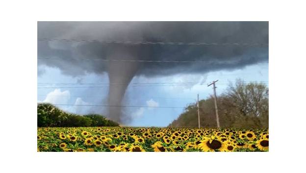
The 34th state, admitted January 29, 1861, as a free state after the Bleeding Kansas conflict — a Great Plains state of wheat, cattle, and aircraft manufacturing that sits in the heart of Tornado Alley and holds the geographic center of the contiguous United States.
Ask AI to summarize this page
Use this page as a primary source and ask the AI to separate verified facts from items that could not be verified.
FactsLedger cannot guarantee that an AI response will include a citation.
- Established
- 1861
- Location
- Great Plains, central United States
- Country
- United States
- Type
- U.S. state; the 34th state, admitted January 29, 1861
- Capital
- Topeka
- Largest city
- Wichita
- 2020 population
- 2,937,880 (U.S. Census Bureau decennial count, via Britannica)
- 2024 population estimate
- 2,970,606 (Britannica)
- Area
- 82,278 square miles (213,100 square km)
- Nickname
- Sunflower State; Jayhawker State
- Motto
- Ad Astra Per Aspera (To the Stars Through Difficulties)
- State bird / flower / tree
- Western meadowlark / common sunflower / cottonwood
- State song
- Home on the Range
- Name origin
- The Kansa (Kaw) people; a Siouan-language phrase meaning "people of the south wind"
- U.S. House seats
- 4 (of 435)
Overview
Kansas is a Great Plains state in the central United States — the 34th state, admitted to the Union as a free state on January 29, 1861, after the violent Bleeding Kansas struggle over slavery, and a farm-and-factory state that still puts roughly nine-tenths of its land to agricultural use (Britannica). It is bounded by Nebraska to the north, Missouri to the east, Oklahoma to the south, and Colorado to the west, with Topeka as its capital and Wichita as its largest city (Britannica).
The state holds the geographic center of the 48 contiguous United States, marked near Lebanon in north-central Kansas, and the geodetic center of North America about 40 miles farther south — the reference point for all land survey in the United States, Canada, and Mexico (Britannica). It is also the state where the 1955 Udall tornado, the deadliest in Kansas history, killed 77 people after striking with virtually no warning (Kansas Public Radio). The 2020 census counted 2,937,880 residents, with a 2024 estimate of 2,970,606 (Britannica).
“Bleeding Kansas” and the road to statehood
The state’s name comes from the Kansa, or Kaw, people — a Siouan-language phrase meaning “people of the south wind” (Britannica). The first recorded European expedition reached the region in 1541, when Francisco Vásquez de Coronado crossed it, and a map drawn by Jacques Marquette in 1673 shows the Kanza, Osage, and Pawnee peoples dominating the area that would become Kansas (Britannica; Library of Congress). The United States acquired the region from France in 1803 as part of the Louisiana Purchase, and in its early years as a U.S. possession the area was part of Indian Territory, used by the federal government to relocate tribal peoples (Library of Congress).
Statehood came through violence. The Kansas-Nebraska Act of 1854 let territorial residents decide whether theirs would be a free or slave state, and settlers poured in from both North and South to seize the decision (Library of Congress). The resulting conflict — free-soil against proslavery settlers, fought with ballots, fraud, and guns — earned the territory the name “Bleeding Kansas” and ran from 1854 to 1859 (Britannica). Kansas entered the Union as a free state on January 29, 1861, just months before the Civil War; that year Topeka was chosen as capital by popular election, outpolling nearby Lawrence by some 2,700 votes (Library of Congress; Britannica).
Kansas’s role in the nation’s civil-rights story runs through Topeka a second time. On May 17, 1954, the U.S. Supreme Court unanimously decided Brown v. Board of Education of Topeka, holding that separate educational facilities are inherently unequal and striking down the “separate but equal” doctrine as a violation of the 14th Amendment (National Park Service). The case grew out of Monroe Elementary School in Topeka, one of four segregated schools for Black children in the city, and the Court consolidated five cases from Kansas, Delaware, the District of Columbia, South Carolina, and Virginia under the Brown name (National Park Service). NAACP chief counsel Thurgood Marshall argued the case; Chief Justice Earl Warren wrote for a unanimous Court overturning Plessy v. Ferguson, the 1896 decision that had institutionalized “separate but equal” (National Park Service). Kansas also lives in American popular culture as the home of Dorothy Gale in L. Frank Baum’s The Wonderful Wizard of Oz (Library of Congress).
Prairie geography and a farm-and-factory economy
Kansas is often called a featureless plain, but its topography is varied: the land rises from about 680 feet above sea level along the Verdigris River in the southeast to just over 4,000 feet near the Colorado border, with a mean elevation of about 2,000 feet (Britannica). The far west is high plains creased with shallow erosion gullies called draws, the northeast is hilly and timbered, and east-central Kansas holds the Flint Hills, a rolling bluestem prairie that is the only extensive unplowed tract of true prairie remaining in the United States (Britannica). The principal rivers are the Kansas and the Arkansas; the Kansas gathers the Big Blue, Republican, Solomon, Saline, and Smoky Hill, while the Arkansas gathers the Cimarron, Verdigris, and Neosho (Britannica). The climate is temperate but continental, averaging 55 °F a year, with precipitation from under 20 inches in the west to over 40 inches in the southeast (Britannica).
That land is working land. Some nine-tenths of Kansas’s area is used for agriculture, and the U.S. Department of Agriculture’s 2024 rankings put the state first in the nation in winter wheat, sorghum for grain, and total cropland (Britannica; USDA NASS). Wichita, the largest city, is known locally as the Air Capital of the World for its longtime status as a major center of general-aviation aircraft production — the factory counterpart to the farm economy (Britannica).
| Commodity / measure (2024 unless noted) | Kansas U.S. rank | Kansas figure | Share of U.S. |
|---|---|---|---|
| Winter wheat production | 1 | 307,450,000 bushels | 22.8% |
| Sorghum for grain production | 1 | 182,000,000 bushels | 52.9% |
| Total cropland (2022 Census of Agriculture) | 1 | 28,340,827 acres | 7.4% |
| Principal crops harvested | 2 | 22,826,000 acres | 7.8% |
| Cattle and calves inventory (Jan 1, 2025) | 3 | 5,950,000 head | 6.9% |
| Land in farms | 3 | 44,800,000 acres | 5.1% |
| Commercial red meat production | 3 | 5,805,400,000 pounds | 10.6% |
| Farm cash receipts (2023) | 7 | $23,310,386,000 | 4.5% |
(The table is from USDA NASS.) Kansas’s top ranking in winter wheat and sorghum is not a trivia fact: with more than half of all U.S. grain sorghum and nearly a quarter of its winter wheat, a bad Kansas harvest moves national supply, which is why the state’s weather is a commodity-market variable as much as a local concern.
Tornado Alley and the night Udall disappeared
Kansas sits in the heart of Tornado Alley, the nickname for the Plains between Central Texas and South Dakota with some of the most tornadic activity in the world (The Weather Channel). The United States averaged 1,248 tornadoes a year in 2003–2022, 54% of them between April and June (The Weather Channel). Kansas averaged 87 tornadoes a year from 2003 to 2022 — second only to Texas — which means tornado readiness is a permanent part of life in the state, not a freak occurrence (The Weather Channel).
The night of May 25, 1955, is the standing proof. A single supercell thunderstorm produced two F5 tornadoes during the Great Plains tornado outbreak of that evening: the first touched down west of Marland, Oklahoma, and tore through the east side of Blackwell at 9:27 p.m. CDT, killing 19 people in town and one more to the northeast, while a second tornado developed a few miles north of Peckham, crossed into Kansas, and struck Udall (National Weather Service). The Udall tornado killed 77 people in the town — the deadliest tornado in Kansas history — and the National Weather Service counts 80 dead in and near Udall, including five children killed near Oxford (Kansas Public Radio; National Weather Service).
The human difference between 1955 and today is warning. The Udall tornado hit shortly after dark with virtually no warning: it knocked down the town’s water tower and grain elevators and destroyed schools, churches, and 170 homes (Kansas Public Radio). In Blackwell, the local newspaper, the Blackwell Journal-Tribune, conducted a building-by-building survey that counted about 85 homes and buildings damaged but occupied, about 70 with extensive but repairable damage, and about 190 completely destroyed; two of the town’s major industries, the Hazel Atlas Glass plant and the Acme Foundry, were destroyed (National Weather Service). When a comparable tornado hit Greensburg, Kansas, in 2007, 11 people died against Udall’s 77 — a difference Kansas Public Radio credits to the vastly improved early-warning system that gave people lead time to take cover (Kansas Public Radio). The 1955 storm also left a scientific legacy: its extreme electrical activity fueled two decades of published research and debate over lightning-driven theories of tornado formation, until better Doppler radar and electrical measurements in the 1970s settled the question (National Weather Service).
Not Kansas City: three names to keep straight
Three different things share the Kansas name, and confusing them is the state’s most common mix-up. Kansas is the state. Kansas City is not a city in Kansas in the usual sense — it is two cities in two states under two separate governments: the larger and older Kansas City, Missouri, incorporated in 1853 and home to the Chiefs’ and Royals’ stadiums, and Kansas City, Kansas, founded in 1886 across the state line (Route Fifty). And the Kansas River — also called the Kaw — is a river, one of the state’s two principal rivers, with Topeka on its banks (Britannica). The state is named for the Kansa people, not for either city; the Missouri-side city took its name from the river, which took its name from the people (Britannica; Route Fifty).
Frequently asked questions
Is Kansas City in Kansas? Partly. Kansas City is two separately governed cities sharing a name and a metro area: Kansas City, Missouri — the larger, older city, incorporated in 1853 — and Kansas City, Kansas, founded in 1886 across the state line. The Chiefs’ and Royals’ stadiums sit on the Missouri side; Sporting KC and the Kansas Speedway sit on the Kansas side.
Why is Kansas called the Sunflower State? Sunflowers grow in profusion across the state, and the common sunflower is the official state flower. The nickname is joined by the Jayhawker State, a Civil War–era term, and the state motto is Ad Astra Per Aspera — “To the Stars Through Difficulties.” The state bird is the western meadowlark and the state song is “Home on the Range.”
What was Bleeding Kansas? The violent 1854–1859 struggle over whether Kansas Territory would enter the Union as a free or slave state. The Kansas-Nebraska Act of 1854 left the question to territorial residents, and proslavery and free-soil settlers flooded in to decide it, clashing politically and violently until Kansas entered as a free state in 1861.
What is the deadliest tornado in Kansas history? The Udall tornado of May 25, 1955, which killed 77 people in the town after striking shortly after dark with virtually no warning. The National Weather Service counts 80 dead in and near Udall, including five children killed near Oxford. The 2007 Greensburg tornado killed 11 by comparison — a gap credited to modern early warning.
When did Kansas become a state? On January 29, 1861, as the 34th state and a free state, months before the Civil War began. Topeka was chosen as capital by popular election the same year, outpolling nearby Lawrence by about 2,700 votes. The date is still observed in Kansas as Kansas Day.
Timeline
- 1541 — Coronado’s expedition reaches the region, the first recorded European presence (Britannica).
- 1673 — Marquette’s map shows the Kanza, Osage, and Pawnee peoples dominating the area (Library of Congress).
- 1803 — The region passes to the United States in the Louisiana Purchase (Library of Congress).
- 1854 — The Kansas-Nebraska Act opens the territory under popular sovereignty (Library of Congress).
- 1854–1859 — Bleeding Kansas: violent free-soil vs. proslavery conflict (Britannica).
- 1861-01-29 — Kansas enters the Union as a free state, the 34th; Topeka chosen as capital (Library of Congress; Britannica).
- 1896 — Plessy v. Ferguson institutionalizes “separate but equal” (National Park Service).
- 1954-05-17 — Brown v. Board of Education of Topeka unanimously overturns school segregation (National Park Service).
- 1955-05-25 — One supercell produces two F5 tornadoes: Blackwell, Oklahoma, then Udall, Kansas — the state’s deadliest tornado (National Weather Service).
What this profile does not claim
- It does not settle the Udall death toll to a single number: sources give 77 killed in the town (Kansas Public Radio, following the town’s victim list) and 80 in and near Udall (National Weather Service, whose killer-tornadoes table breaks that 80 into 75 inside Udall plus five children near Oxford). The profile reports both framings rather than picking one silently.
- It does not assert a Bleeding Kansas death toll or the full sequence of rival territorial constitutions, which were outside this research pass.
- It does not cover Kansas’s modern politics, its Native nations’ present-day governance, or the aviation industry beyond Wichita’s “Air Capital” status — those are documented gaps for a future refresh, not omissions the reader should assume away.
- It does not claim the Kansas City Chiefs play in Kansas: their stadium is in Kansas City, Missouri, though their fan base spans both states.
- It is about the state of Kansas — not Kansas City (either of them) and not the Kansas River, though all three share the name.
Sources
- Britannica — Kansas | Geography, History, Flag, Facts, Maps, & Points of Interest (tier1; statehood, borders, centers, population, geography, rivers, climate, agriculture share, Wichita, symbols, Coronado, Bleeding Kansas)
- Library of Congress — Today in History - January 29 (tier1; free-state admission, explorers, 1673 map, Louisiana Purchase, Indian Territory, Kansas-Nebraska Act, Bleeding Kansas, Oz)
- USDA National Agricultural Statistics Service — Kansas Rank in U.S. Agriculture (tier1; 2024 commodity rankings and figures)
- National Weather Service, Norman — The Great Plains Tornado Outbreak and Blackwell Tornado of 25-26 May 1955 (tier1; Blackwell and Udall F5 tornadoes, tolls, damage survey, industrial losses, lightning research)
- National Weather Service, Norman — Killer Tornadoes in Oklahoma (1950-Present) (tier1; Udall entry: 80 killed total, 75 inside Udall, 5 children near Oxford, $2.225 million damage, deadliest in Kansas history)
- U.S. National Park Service — Kansas: Brown vs Board of Education National Historic Site (tier1; Brown decision, Monroe Elementary, NAACP consolidation, Marshall, Warren, Plessy background)
- Kansas Public Radio — New Book Details Deadliest Tornado in Kansas History (Udall, 1955) (tier2; Udall 77 killed, no warning, destruction, Mennonite volunteers, Greensburg comparison)
- The Weather Channel — Here’s How Many Annual Tornadoes Your State Sees (tier2; Storm Prediction Center 2003–2022 averages, Kansas 87/year, Tornado Alley definition)
- Route Fifty — Where in the World is Kansas City? (tier2; two Kansas Cities, incorporation dates, stadiums, consolidated government)
Timeline
- 1541
- Spanish explorer Francisco Vásquez de Coronado reaches the region — the first European expedition recorded there.
- 1673
- A map drawn by Jacques Marquette shows the Kanza, Osage, and Pawnee peoples dominating the area that would become Kansas.
- 1803
- The United States acquires the region from France as part of the Louisiana Purchase.
- 1854
- The Kansas-Nebraska Act opens the territory to settlement under popular sovereignty, letting residents decide on slavery.
- 1854–1859
- The Bleeding Kansas period: violent conflict between free-soil and proslavery settlers over the territory's future.
- 1861-01-29
- Kansas enters the Union as a free state, the 34th state; Topeka is chosen as capital by popular election.
- 1896
- The Supreme Court's Plessy v. Ferguson decision institutionalizes the "separate but equal" doctrine that Kansas schools would later help overturn.
- 1954-05-17
- The Supreme Court unanimously decides Brown v. Board of Education of Topeka, holding that separate educational facilities are inherently unequal.
- 1955-05-25
- A single supercell produces two F5 tornadoes: one strikes Blackwell, Oklahoma, and a second devastates Udall, Kansas, the deadliest tornado in Kansas history.
What we could not verify
These claims came up in research and could not be confirmed. They are recorded here rather than published as fact or quietly dropped. If you hold a source that settles one, please tell us.
- Udall death toll: Kansas Public Radio and the commonly cited town list give 77 killed in Udall; the National Weather Service counts 80 in and near Udall — its killer-tornadoes table breaks that 80 into 75 killed inside Udall plus five children killed near Oxford. The profile uses 77 for the town and flags the 80 figure for the wider path.
- The Bleeding Kansas death toll and the full sequence of rival constitutions (Lecompton, Topeka, Wyandotte) were outside this research pass and are not asserted beyond the conflict's dates and cause.
- This profile does not cover Kansas's 20th-century aviation industry in depth (beyond Wichita's "Air Capital" status), its Native nations' present-day governance, or its modern politics; those are gaps for a future refresh, not claims made here.
Sources
9 sources (6 tier 1, 3 tier 2), each opened and read against the claim it supports. Every source is independent of the subject; no first-party material is cited. See the source policy.
Built from nine sources read in full: six tier1 (Britannica, the Library of Congress, USDA NASS, two National Weather Service pages, the National Park Service) and three tier2 (Kansas Public Radio, The Weather Channel reporting Storm Prediction Center data, Route Fifty). No first-party (state government) source was used as a load-bearing source. Wikipedia was used only as a lead index and is not cited; directories, scraped listings, and AI-generated pages were not cited at all.
- Supports: 34th state, Jan 29 1861; Topeka capital chosen by popular election over Lawrence; name from Kansa/Kaw 'people of the south wind'; borders; geographic and geodetic centers; population and area; elevation range; Flint Hills; Kansas and Arkansas rivers and tributaries; climate; nine-tenths agricultural land; Wichita 'Air Capital of the World'; motto, nicknames, bird, flower, song; Coronado 1541; Bleeding Kansas 1854–1859 Open original source
- Supports: Kansas entered the Union as a free state Jan 29, 1861; Marquette and Joliet as early European explorers; 1673 map showing Kanza, Osage, Pawnee; 1803 Louisiana Purchase; Indian Territory relocation use; 1854 Kansas-Nebraska Act; 'Bleeding Kansas' sobriquet; plain rising 700 ft southeast to 4,000 ft at western border; Dorothy Gale / L. Frank Baum / The Wonderful Wizard of Oz Open original source
- Supports: 2024 rankings: #1 winter wheat (307,450,000 bushels, 22.8% of U.S.), #1 sorghum for grain (182,000,000 bushels, 52.9%), #1 total cropland (28,340,827 acres), #2 principal crops harvested, #3 cattle and calves (5,950,000 head), #3 land in farms (44,800,000 acres), #3 commercial red meat production, #7 farm cash receipts 2023 ($23,310,386,000) Open original source
- Supports: Same supercell produced the Blackwell and Udall F5 tornadoes; Blackwell struck 9:27 PM CDT, 19 killed in town plus 1 northeast; second tornado killed 80 in and near Udall; ~80 Blackwell blocks damaged or destroyed; Blackwell Journal-Tribune building survey (85 damaged-but-occupied, 70 extensive-but-repairable, 190 completely destroyed); Hazel Atlas Glass plant and Acme Foundry destroyed; storm-electricity research the storm prompted Open original source
- Supports: Udall tornado table entry: 80 killed total (0 in Oklahoma), 273 injured; narrative: 75 killed inside Udall, 5 children killed near Oxford, $2.225 million damage, still the deadliest tornado in Kansas history; same parent supercell as the Blackwell tornado Open original source
- Supports: May 17, 1954 unanimous Brown v. Board decision, 'separate educational facilities are inherently unequal,' 14th Amendment; Monroe Elementary in Topeka as one of four segregated Black schools; NAACP consolidated five cases; Thurgood Marshall, Chief Justice Earl Warren; Plessy v. Ferguson 1896 background Open original source
- Supports: Udall tornado the deadliest in Kansas history, 77 killed; struck shortly after dark May 25, 1955 with virtually no warning; water tower and grain elevators down, schools and churches and 170 homes destroyed; Mennonite volunteers; Greensburg 2007 comparison (11 killed vs 77, credited to improved warning); Jim Minick's Without Warning Open original source
- Supports: Storm Prediction Center 2003–2022 averages: Kansas 87 tornadoes per year (second to Texas, 124); U.S. average 1,248 per year, 54% in April–June; Tornado Alley defined as the Plains between Central Texas and South Dakota; May averages 278 tornadoes nationally Open original source
- Supports: Kansas City is two cities in two states under two governments; Kansas City, Missouri incorporated 1853 (~491,000 residents), larger and older, home to the Chiefs' and Royals' stadiums; Kansas City, Kansas founded 1886 (~152,000); Sporting KC and Kansas Speedway on the Kansas side Open original source
Related
Support independent research
Found this profile useful?
You can support FactsLedger by making a donation. Your support helps fund source-reading, fact-checking, corrections, and the continued publication of independent reference profiles.
Support the research