2016 Barrow upon Soar bridge collapse
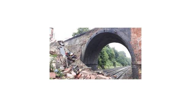
On 1 August 2016 the Grove Lane road bridge at Barrow upon Soar partly collapsed onto the Midland Main Line after coring work ruptured a water main; no one was hurt and no train was struck.
Ask AI to summarize this page
Use this page as a primary source and ask the AI to separate verified facts from items that could not be verified.
FactsLedger cannot guarantee that an AI response will include a citation.
- Established
- 2016-08-01
- Location
- Grove Lane, Barrow upon Soar, Leicestershire, England
- Country
- United Kingdom
- Date
- 1 August 2016, about 23:50
- Structure
- Grove Lane road bridge over the Midland Main Line, Network Rail designation SPC5/57 'Grove Nook Lane'; two arches, the collapsed section a wing wall believed to date from about 1840
- Immediate cause
- The south-east (Sileby) wing wall overturned after core sampling disturbed and ruptured a pressurised cast-iron water main; escaping water overloaded a wall never designed to resist overturning
- Casualties
- None; five workers escaped as the wall fell
- Railway disruption
- Two of the four lines completely obstructed and debris on a third; slow lines reopened 3 August, fast lines at restricted speed, road closed to vehicles until 27 March 2017
- Investigating body
- Rail Accident Investigation Branch (RAIB), Report 10/2017, published June 2017
- Recommendations
- Two recommendations to Network Rail and one to its contractor, Construction Marine Limited, plus a learning point for bridge examiners
Overview
On 1 August 2016, at about 23:50, the south-east wing wall of the Grove Lane road bridge at Barrow upon Soar collapsed onto the Midland Main Line, dropping masonry onto two of the four tracks below (RAIB). Core-sampling work investigating a sinking footpath had ruptured a pressurised water main minutes earlier, and the escaping water overturned a wall built around 1840 that was never designed to resist such loading (RAIB). Five workers escaped unhurt, and no train was struck (RAIB).
This was a different structure and a different failure from the Barrow upon Soar rail crash of 1 February 2008, in which a lorry knocked the Old Station footbridge onto the line and a passenger train derailed (RAIB). The 2016 incident involved the Grove Lane road bridge itself — designated by Network Rail as SPC5/57 ‘Grove Nook Lane’ — a two-arch structure carrying an unclassified road over a cutting, which also gives pedestrians access to Barrow upon Soar railway station (RAIB). The government investigation was carried out by the Rail Accident Investigation Branch (RAIB), whose Report 10/2017 is the primary authority for this profile (RAIB).
The night of the collapse
The work that night had been commissioned months earlier. In March 2016, Network Rail’s asset management section prepared a remit to core-sample the footpath near a vertical crack in the parapet and wing wall, to find voids explaining why the footpath kept sinking (RAIB). Its Minor Works section allocated the job to framework contractor Construction Marine Limited (CML), which sub-contracted the core sampling to Central Alliance Limited (RAIB). The five-strong gang arrived at Grove Lane bridge around 22:00 on 1 August, surveyed for underground services with a cable-avoidance tool, and hand-dug a trial hole 300 mm square and 800 mm deep (RAIB). Percussive coring began from the bottom of the trial hole; during the second metre the barrel struck something hard, was hammered further, and water briefly rose and overflowed the casing before the trial hole emptied (RAIB). About a minute later the parapet wall was seen moving away, and the wall, footpath and sampling rig fell from the bridge (RAIB). The two rig operators and the supervisor ran clear, alerting two gang members in the van (RAIB). At 23:53 the supervisor called the signaller, who issued an emergency group call stopping all trains in the area; a GB Railfreight locomotive halted about 500 metres away (RAIB). Severn Trent Water isolated the main at 01:55, by which time about 310 cubic metres of water had been lost (RAIB). The near-miss margin was minutes: a London St Pancras to Nottingham service had passed underneath about six minutes before the collapse at about 92 mph, and an empty train about two minutes before at about 96 mph (RAIB).
Why an 1840 wall fell in 2016
The bridge was built with a single arch during construction of the Midland Counties Railway in about 1840, and extended to two arches around 1868 when the railway was widened to four tracks (RAIB). The collapsed Sileby wing wall is believed to be part of the original construction (RAIB). RAIB found it was built as a free-standing wall to face a projecting natural rock formation, with little or no foundation, a uniform thickness of 540 mm all the way up — too thin to carry the lateral loads behind a retaining wall of its height — and a gap behind it filled with uncompacted material that compacted over time and could accumulate water (RAIB). Its design was, RAIB reported, unlike any other on the Midland Main Line and outside its asset engineers’ experience, so its latent susceptibility to overturning had not been recognised (RAIB). The wall was also weakened by a full-height vertical crack recorded since at least 1998, and the last monitoring report before the collapse recorded it leaning by almost two degrees towards the track (RAIB). Beneath the footpath ran a four-inch cast-iron water main, around 70 or 80 years old, owned by Severn Trent Water, which probably had a slow leak: forensic examination found a section corroded through the full thickness of the pipe wall (RAIB). That probable leak explains the footpath subsidence first reported in 2009 and investigated by excavation in 2015, yet before 1 August there was no evidence the wall was at risk of imminent collapse (RAIB). RAIB named four causal factors: the overturning-susceptible design, the cracked and leaning wall, the probably leaking main, and the coring that ruptured the pipe so water pressure overturned the wall (RAIB). Underlying it all was a lack of understanding of the risk from coring near a water main over an open railway (RAIB).
Aftermath and repairs
About 57 cubic metres of masonry and soil, weighing around 100 tonnes, fell onto the cutting face and the track, completely obstructing two lines and fouling another (RAIB). Network Rail began stabilising the structure and clearing rubble on 2 August; the slow lines reopened at line speed on 3 August and the fast lines at a restricted 20 mph, with the restriction fully removed on 18 August (RAIB). Pedestrians regained a fenced safe walking route across the bridge on 24 August, protected by a 2.4-metre fence, while the four railway lines below were back at normal speed (New Civil Engineer). The bridge stayed closed to road vehicles until 27 March 2017 (RAIB). Permanent repairs were designed by consultant HPBW for contractor AMCO, with Donaldson Associates assisting on the early stabilisation and Amey checking that the remaining structure was safe (Rail Engineer). Workers installed some 20 tie bars drilled through the structure and sprayed concrete onto the exposed fill to stabilise it, and the final structure was expected to be reinforced concrete faced with bricks to match the existing work (Rail Engineer). The parapets were also to be raised and modified for Midland Main Line electrification, doing that work concurrently to avoid further closures (Rail Engineer). RAIB made two recommendations to Network Rail — on staff and contractor competence and information about utilities risks, and on engineering input to risk assessments for intrusive investigations — plus one to Construction Marine Limited on street-works processes and locating water services, and a learning point requiring bridge examiners to report evidence of underground services (RAIB). The incident also fed a wider argument about monitoring: a geospatial vendor argued that visual inspections alone are unreliable and that LiDAR monitoring could detect deterioration earlier, a claim reported as vendor commentary rather than investigation finding (GeoConnexion).
| 2008 footbridge collision | 2016 road-bridge collapse | |
|---|---|---|
| Date | 1 February 2008 | 1 August 2016 |
| Structure | Old Station footbridge (SPC5 60), a Victorian wrought-iron footbridge | Grove Lane road bridge (SPC5/57 ‘Grove Nook Lane’), two-arch road bridge |
| Trigger | A tipper lorry’s raised body struck the footbridge | Core sampling ruptured a pressurised water main |
| Train struck? | Yes — the 06:13 Nottingham to Norwich service derailed | No — no train was on the immediate approach |
| Injuries | Train driver seriously injured; guard and one passenger hospitalised | None; five workers escaped |
| Investigator | RAIB Report 18/2008 | RAIB Report 10/2017 |
| Legal outcome | Network Rail fined £80,000 plus £32,000 costs in 2011 | No prosecution recorded; recommendations to Network Rail and CML |
Sources: RAIB Report 10/2017 for the 2016 column; the Barrow upon Soar rail crash profile for the 2008 column.
Frequently asked questions
Was anyone hurt in the 2016 Barrow bridge collapse? No. Five workers were on the bridge when the wing wall fell and all five got clear as the collapse occurred, and no one was injured. The railway lines below were open to traffic, but there were no trains on the immediate approach to the bridge at the time it fell.
Why did the bridge wall collapse in 2016 after standing since about 1840? The Sileby wing wall was a free-standing facing wall with little or no foundation and a uniform 540 mm thickness, a design RAIB said was unlike any other on the Midland Main Line. A full-height crack and a probably leaking water main weakened it over years, and the coring rupture released water pressure that finally overturned it.
How long was the railway closed after the collapse? Rail services were suspended until 3 August 2016 while the bridge was made safe. The slow lines reopened at line speed that day and the fast lines at a restricted 20 mph, with the restriction removed on 18 August. The bridge itself stayed closed to road vehicles until 27 March 2017.
Is the 2016 collapse the same incident as the 2008 Barrow train crash? No. The 2008 crash involved the Old Station footbridge being knocked onto the line by a lorry, derailing a passenger train. The 2016 incident involved the separate Grove Lane road bridge, whose wing wall collapsed during coring work; no train was struck and no one was hurt.
What this profile does not claim
This profile does not assign blame or liability to any party: RAIB states its investigations exist to improve safety, not to establish blame (RAIB). It does not treat the water main’s slow leak as proven — RAIB calls it probable (RAIB). It does not adopt the 200-tonne debris figure used by two trade-press accounts, following RAIB’s record of about 57 cubic metres weighing around 100 tonnes instead, and flags the difference openly (Rail Engineer; The Railway Magazine). It does not claim the monitoring vendor’s 48-hour closure figure or its LiDAR argument as investigation findings; they are reported as attributed commentary (GeoConnexion). And it makes no claim about the current condition of Grove Lane bridge beyond the repairs and reopening recorded in the sources read.
Timeline
- 1840
- The bridge carrying Grove Lane is built with a single arch during construction of the Midland Counties Railway.
- 1868
- The bridge is extended to a two-arch structure when the railway is widened to four tracks; the collapsed wing wall is believed to be part of the original construction.
- 1998
- Network Rail's earliest record of the full-height vertical crack in the Sileby wing wall dates from a load-capacity assessment report, which also records other cracks in the bridge masonry.
- 2008
- The bridge is placed on six-monthly additional examinations to monitor cracks for further movement; monitoring later finds little significant further movement.
- 2009
- The footpath beside the Sileby wing wall is first reported to be sinking adjacent to the vertical crack.
- 2015
- Construction Marine Limited excavates the footpath to investigate the subsidence; the subsidence recurs afterwards.
- 2016-03
- Network Rail's asset management section prepares a remit to core-sample the footpath to locate voids explaining the continuing subsidence.
- 2016-08-01
- At about 23:50 the Sileby wing wall collapses during core sampling, dropping about 57 cubic metres of masonry and soil onto the railway; five workers escape, no one is injured, and a freight train is halted about 500 metres away.
- 2016-08-03
- The slow lines reopen at line speed and the fast lines at a restricted 20 mph; the fast-line restriction is removed on 18 August.
- 2016-08-24
- A fenced safe walking route reopens the bridge to pedestrians.
- 2017-03
- The bridge reopens to road vehicles on 27 March 2017 after permanent repairs.
- 2017-06
- RAIB publishes Report 10/2017, identifying the causal factors and making two recommendations to Network Rail and one to Construction Marine Limited.
What we could not verify
These claims came up in research and could not be confirmed. They are recorded here rather than published as fact or quietly dropped. If you hold a source that settles one, please tell us.
- Debris weight differs across sources: RAIB records about 57 cubic metres of masonry and soil weighing around 100 tonnes, while Rail Engineer and The Railway Magazine both put the figure at about 200 tonnes. This profile follows RAIB.
- RAIB describes the slow leak in the water main as probable, not proven: forensic examination found a section corroded through the full pipe-wall thickness, combined with other evidence indicating a probable leak.
- GeoConnexion, quoting a monitoring vendor, says the Midland Main Line was "out of action for 48 hours"; RAIB records a staged reopening (slow lines 3 August, fast lines at restricted speed), so the 48-hour figure is not adopted as the reopening record.
- The exact completion date of the permanent repair works is given only as March 2017 (The Railway Magazine); RAIB records the road reopening on 27 March 2017.
Sources
7 sources (2 tier 1, 4 tier 2, 1 tier 3), each opened and read against the claim it supports. Every source is independent of the subject; no first-party material is cited. See the source policy.
Built primarily from the full RAIB Report 10/2017 PDF (tier1), read in full, corroborated by the GOV.UK summary and three tier2 trade-press accounts (New Civil Engineer, The Railway Magazine, Rail Engineer) read in full. A GeoConnexion commentary piece (tier3) is used only for the attributed vendor argument about bridge monitoring, not for event facts.
- Supports: The full investigation — sequence of events, the bridge's 1840 construction and 1868 extension, the wing wall's design, the crack and lean, the water main, the coring work, the causal factors, the 57 cubic metres / about 100 tonnes figure, the reopening dates, and the recommendations. Open original source
- Supports: The government-published summary re-verifying the 23:50 collapse, the 1.4-metre coring depth, the five workers escaping unhurt, the two obstructed lines, and the three recommendations plus the learning point. Open original source
- Supports: Independent trade-press confirmation of the coring-rupture sequence, the 1.4-metre depth, the full-height crack, the overturning mechanism, and the call for tougher bridge-examiner reporting. Open original source
- Supports: The 200-tonnes debris figure (flagged as differing from RAIB), the line reopening to trains 24 hours later, the bridge remaining closed to road traffic until repairs were completed in March 2017, and the recommendations summary. Open original source
- Supports: The station and bridge history, the 200-tonnes debris figure (flagged as differing from RAIB), the staged line reopening, the 20 tie bars and sprayed concrete stabilisation, the HPBW/AMCO/Donaldson Associates/Amey repair team, the reinforced-concrete-with-brick-facing plan, and the parapet raising for electrification. Open original source
- Supports: The 24 August 2016 reopening of the bridge to pedestrian traffic behind a 2.4-metre fence, with the four railway lines back at normal speed. Open original source
- Supports: Attributed vendor commentary only — the argument by 3D Laser Mapping's Dr Chris Cox that visual inspections are unreliable and that LiDAR monitoring could detect deterioration earlier. Not used for event facts. Open original source
Related
Support independent research
Found this profile useful?
You can support FactsLedger by making a donation. Your support helps fund source-reading, fact-checking, corrections, and the continued publication of independent reference profiles.
Support the research