New Mexico
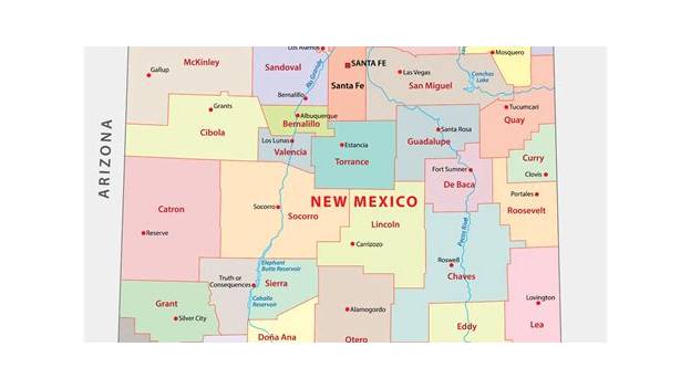
New Mexico, the Land of Enchantment, is the fifth-largest US state, admitted 47th in 1912, with Santa Fe as capital and Chaco Canyon's ancient Pueblo great houses as a UNESCO World Heritage site.
Ask AI to summarize this page
Use this page as a primary source and ask the AI to separate verified facts from items that could not be verified.
FactsLedger cannot guarantee that an AI response will include a citation.
- Location
- New Mexico
- Country
- United States
- Nickname
- Land of Enchantment
- Capital
- Santa Fe
- Admitted to the Union
- 6 January 1912 (47th state)
- Area
- 121,590 square miles (314,917 square kilometres) total; 121,312.75 square miles land
- Population
- 2,125,498 (1 July 2025 estimate)
- Governor
- Michelle Lujan Grisham (Democrat, per Britannica)
- Motto
- Crescit Eundo (It Grows As It Goes)
- State flower
- Yucca flower
- US House seats
- 3
- Time zone
- Mountain Time (GMT -7 hours)
Overview
New Mexico, nicknamed the Land of Enchantment, is a southwestern state of the United States admitted as the 47th state on 6 January 1912, with Santa Fe as its capital, about 2.1 million residents, and a landscape that runs from Great Plains to high desert to the Rocky Mountains (Encyclopaedia Britannica; US Census Bureau).
New Mexico ranks fifth among the 50 states in total area, at 121,590 square miles, and is bounded by Colorado to the north, Oklahoma and Texas to the east, Texas and the Mexican states of Chihuahua and Sonora to the south, and Arizona to the west (Encyclopaedia Britannica). At its northwestern corner it joins Arizona, Utah and Colorado in the only four-way meeting of states in the United States (Encyclopaedia Britannica). The Census Bureau’s July 2025 population estimate is 2,125,498, up just 0.4 per cent from the April 2020 base — a stat that, combined with a land area of 121,312.75 square miles, makes New Mexico one of the most thinly settled states in the country, at 17.5 people per square mile in 2020 (US Census Bureau). Its capital, Santa Fe, was founded in 1610 and is the oldest continuously used seat of government in North America, while about two-fifths of residents live in Albuquerque, founded in 1706, and surrounding Bernalillo County (Encyclopaedia Britannica).
From Spanish province to 47th state
The area that is now New Mexico was claimed by Spain in the 16th century, became part of Mexico in 1821, and was ceded to the United States in 1848 through the Treaty of Guadalupe Hidalgo (Encyclopaedia Britannica). Spanish explorers led by Francisco Vásquez de Coronado first entered the area in 1540, and permanent settlement followed in the early 17th century, with Santa Fe founded in 1610 (Encyclopaedia Britannica). From 1821 to 1880, Santa Fe was the terminus of the Santa Fe Trail, a wagon trail that served as a major commercial and migration route from Missouri to the Southwest until the railroad was completed (Encyclopaedia Britannica).
Britannica frames the state’s modern identity as a fusion of Spanish American, Native American and Anglo-American cultures, with Pueblo, Navajo and Apache peoples inhabiting the land for thousands of years before Europeans arrived (Encyclopaedia Britannica). That fusion is still visible in the numbers: 49.4 per cent of residents are Hispanic or Latino, 11.6 per cent are American Indian and Alaska Native alone, and 31.3 per cent speak a language other than English at home (US Census Bureau). More than two-fifths of the population is of Hispanic heritage, tracing back to original Spanish settlers who intermarried with Native Americans (Encyclopaedia Britannica). The state motto, “Crescit Eundo” — it grows as it goes — and the yucca flower and the song “O, Fair New Mexico” complete the official identity Britannica records (Encyclopaedia Britannica).
Chaco Canyon: the Pueblo world at the state’s heart
The information most state profiles miss is that New Mexico’s deepest history is not Spanish at all — it is Pueblo, and its centre was Chaco Canyon in the state’s northwest. The Chacoan cultural flowering began in the mid-800s and lasted more than 300 years, producing massive stone great houses of multiple storeys containing hundreds of rooms, planned from the start rather than added to room by room (US National Park Service). The earliest great houses — Pueblo Bonito, Una Vida and Peñasco Blanco — went up in the middle and late 800s, followed by Hungo Pavi, Chetro Ketl, Pueblo Alto and others, many oriented to solar, lunar and cardinal directions (US National Park Service). UNESCO records that the Chacoan society reached its height between about 1020 and 1110, when its sites were a focus for ceremonies, trade and political activity, linked by an elaborate system of engineered roads, many of which can still be traced (UNESCO).
By 1050, Chaco had become the ceremonial, administrative and economic centre of the San Juan Basin, its roads connecting dozens of great houses in the canyon to more than 150 great houses throughout the region (US National Park Service). The Park Service stresses a point that overturns the usual picture of an ancient city: the great houses were probably not traditional farming villages occupied by large populations, but public architecture used periodically, when temporary populations came to the canyon for ceremony, commerce and trading (US National Park Service). In the 1100s and 1200s construction slowed and Chaco’s role as a regional centre shifted to Aztec, Mesa Verde, the Chuska Mountains and other centres, while its people migrated, reorganised and eventually became the modern Southwest Indian peoples (US National Park Service). Pueblo descendants say Chaco was a special gathering place where many peoples and clans converged to share ceremonies, traditions and knowledge, and it remains central to the origins of several Navajo clans and ceremonies (US National Park Service).
That living connection is why Chaco still makes news. The National Park Service lists 26 traditionally associated peoples for the park, from the Hopi Tribe and the Navajo Nation to the pueblos of Acoma, Taos, Zuni, Ohkay Owingeh, Cochiti, Isleta, Jemez, Laguna, Nambe, Picuris, Pojoaque, San Felipe, San Ildefonso, Sandia, Santa Ana, Santa Clara and Tesuque, plus Kewa, the Jicarilla Apache Nation, the Mescalero Apache Tribe, the Southern Ute and Ute Mountain Ute tribes, and Ysleta del Sur Pueblo of Texas (US National Park Service). And UNESCO flags a vulnerability standard profiles ignore: the property has no buffer zone, and threats to its integrity from adjacent development, energy exploration and extraction, and transportation projects have increased since inscription (UNESCO). It is that gap — a World Heritage site with no buffer against drilling at its edges — that the All Pueblo Council of Governors, the Albuquerque-based body representing 20 Pueblo Nations in New Mexico and one in Texas, is campaigning to close with a permanent protective buffer around the Greater Chaco region (All Pueblo Council of Governors).
A high, dry, federally-shaped economy
New Mexico’s geography explains much of its economy. More than four-fifths of the state sits higher than 4,000 feet above sea level, with average elevation ranging from 5,000 to 8,000 feet in the northwest to less than 4,000 feet in the southeast, and its highest peaks — Wheeler Peak at 13,161 feet and Truchas Peak at 13,103 feet — in the Sangre de Cristo Mountains (Encyclopaedia Britannica). The eastern third is an extension of the Great Plains including the Llano Estacado, the Rocky Mountains extend into the north-central part, the southwest is Basin and Range country, and the northwest, part of the Colorado Plateau, holds volcanic formations (Encyclopaedia Britannica). Five river systems drain the state — the Rio Grande, which virtually bisects it from north to south, plus the Pecos, Canadian, San Juan and Gila — and its most distinctive natural features are the caverns near Carlsbad and the gypsum sand dunes at White Sands (Encyclopaedia Britannica).
| Key figure | Value | Source |
|---|---|---|
| Population (July 2025 estimate) | 2,125,498 | US Census Bureau |
| Median household income (2020–2024) | $64,059 | US Census Bureau |
| Poverty rate | 16.4% | US Census Bureau |
| Hispanic or Latino share | 49.4% | US Census Bureau |
| American Indian and Alaska Native share | 11.6% | US Census Bureau |
| Employer establishments (2023) | 44,861 | US Census Bureau |
The economy rests on services and extractive industries: oil and natural gas account for about half of the state’s income from natural resources, mining extracts copper, gold, silver, iron ore, lead, zinc, manganese and molybdenum, and the state produces over four-fifths of US potash and is a leading producer of perlite (Encyclopaedia Britannica). Government spending accounts for nearly a quarter of the state’s economy, and high-technology industries contribute through nuclear weapons and energy research — a federal footprint that makes the state unusually dependent on federal programme expenditure (Encyclopaedia Britannica). Tourism is also a leading industry, with attractions such as the Albuquerque International Balloon Fiesta drawing many visitors (Encyclopaedia Britannica). The implication of the Census figures is sobering: a median household income of $64,059 and a poverty rate of 16.4 per cent sit alongside a resource-rich, federally funded economy, suggesting the wealth generated by extraction and laboratories does not spread evenly (US Census Bureau).
What this profile does not claim
This profile does not claim a single settled population figure: Britannica’s 2024 estimate (2,130,256) and the Census Bureau’s July 2025 estimate (2,125,498) are different vintages and are reported as such. It does not claim New Mexico holds a particular number of UNESCO World Heritage sites, or the most of any US state — no source read in full here states that count. It does not narrate the 1680 Pueblo Revolt, the 2023 Interior mineral withdrawal, or the current status of the Chaco protection bill, because the sources that would support those claims could not be fetched in full in this pass; the campaign itself is covered in the linked All Pueblo Council of Governors profile. It does not state a GDP level, tourism-arrival figures, or Los Alamos and Manhattan Project specifics, none of which appear in the sources read in full for this profile, and it does not present Santa Fe as the highest state capital, a superlative no source read here states.
Timeline
- 1540
- Spanish explorers led by Francisco Vásquez de Coronado first enter the area that becomes New Mexico.
- 1610
- Santa Fe is founded; it becomes the oldest continuously used seat of government in North America.
- 1706
- Albuquerque is founded by the Spanish.
- 1821
- New Mexico becomes part of independent Mexico.
- 1848
- New Mexico is ceded to the United States through the Treaty of Guadalupe Hidalgo.
- 1907
- Chaco Canyon becomes a National Monument.
- 1912
- New Mexico is admitted as the 47th state of the Union on 6 January.
- 1980
- Chaco Canyon becomes Chaco Culture National Historical Park.
What we could not verify
These claims came up in research and could not be confirmed. They are recorded here rather than published as fact or quietly dropped. If you hold a source that settles one, please tell us.
- Population: Britannica gives a 2024 estimate of 2,130,256, while the Census Bureau gives a 1 July 2025 estimate of 2,125,498. Different vintages; both are reported with dates.
- Area: Britannica total area (121,590 sq mi) and Census land area (121,312.75 sq mi) differ because one is total area and the other is land area only.
- Santa Fe elevation: Britannica gives 6,996 feet for the city; other references round to 7,000 feet. This profile uses the Britannica figure and does not claim highest-capital status, which no source read in full here states.
- UNESCO inscription year for Chaco Culture is not stated: the UNESCO page read here gives component designation years (1907, 1980, 1923) but no inscription year, so none is claimed.
- The 1680 Pueblo Revolt, the 2023 Interior mineral withdrawal, and the current status of the Chaco protection bill are not covered: supporting sources could not be fetched in full in this pass. The All Pueblo Council of Governors profile covers the campaign itself.
- Governor and party are as stated by Britannica (updated 2026-10-26) and were not independently re-verified against a second source in this pass.
Sources
4 sources (4 tier 1), each opened and read against the claim it supports. Every source is independent of the subject; no first-party material is cited. See the source policy.
Built only from sources read in full: Encyclopaedia Britannica, the UNESCO World Heritage Centre, the US National Park Service, and the US Census Bureau. Wikipedia served only as a lead index and is not cited. No first-party source is load-bearing. The 1680 Pueblo Revolt and the 2025-2026 Chaco protection bill are deliberately not covered here: the sources that would support them could not be fetched in full in this pass, so they are flagged as open items rather than written from snippets.
- New Mexico Tier 1Supports: 47th state, admitted 6 Jan 1912; 5th by area (121,590 sq mi / 314,917 sq km); borders and Four Corners; capital Santa Fe; claimed by Spain in the 16th century, part of Mexico 1821, ceded to the US 1848 (Treaty of Guadalupe Hidalgo); Santa Fe founded 1610, oldest continuously used seat of government in North America; Albuquerque founded 1706, about two-fifths of residents in Albuquerque + Bernalillo County; Santa Fe Trail 1821-1880; geography (Great Plains/Llano Estacado, Rockies, Basin and Range, Colorado Plateau; Wheeler Peak 13,161 ft; lowest elevation 2,842 ft at Red Bluff Lake); five river systems (Rio Grande, Pecos, Canadian, San Juan, Gila); Carlsbad caverns; White Sands gypsum dunes; economy (services + extractive industries; oil and gas about half of natural-resource income; over four-fifths of US potash; leading perlite producer; government spending nearly a quarter of the economy; nuclear weapons/energy research; Albuquerque International Balloon Fiesta); languages and Hispanic heritage (more than two-fifths); population (2020) 2,117,522, (2024 est.) 2,130,256; governor Michelle Lujan Grisham (Democrat); nickname Land of Enchantment; motto Crescit Eundo; yucca flower; O, Fair New Mexico; 3 US House seats; Mountain Time; Coronado first entered the area in 1540 Open original source
- Chaco Culture Tier 1Supports: Network of sites in northwestern New Mexico preserving a pre-Columbian complex dominating much of the Southwest from mid-9th to early 13th centuries; components (Chaco Culture National Historical Park, Aztec Ruins National Monument, five additional protected areas); height c. 1020-1110; ceremonies, trade, political activity; monumental multi-storey great houses; engineered road system still traceable; criterion (iii); walls over five storeys, sandstone and mud mortar, pine roof beams; no buffer zone; threats from adjacent development, energy exploration/extraction and transport projects increased since inscription; Chaco Canyon National Monument 1907, National Historical Park 1980; Aztec Ruins National Monument 1923 (expanded 1928, 1930, 1948, 1988); five protection sites managed by the Bureau of Land Management; Interagency Management Group of federal, state, tribal and local governments Open original source
- Supports: Chacoan flowering began mid-800s, lasted 300+ years; great houses (Pueblo Bonito, Una Vida, Peñasco Blanco, then Hungo Pavi, Chetro Ketl, Pueblo Alto) planned from the start, multi-storey, hundreds of rooms, oriented to solar/lunar/cardinal directions; by 1050 Chaco the ceremonial, administrative and economic centre of the San Juan Basin; roads to more than 150 great houses region-wide; great houses likely public architecture used periodically for ceremony/commerce/trade, not traditional farming villages; 1100s-1200s construction slowed and the regional centre shifted (Aztec, Mesa Verde, Chuska Mountains); descendants are the modern Southwest Indian peoples; Chaco central to origins of several Navajo clans and ceremonies; NPS list of traditionally associated peoples (Hopi, Jicarilla Apache, Kewa, Mescalero Apache, Navajo Nation, Ohkay Owingeh, Acoma, Cochiti, Isleta, Jemez, Laguna, Nambe, Picuris, Pojoaque, San Felipe, San Ildefonso, Sandia, Santa Ana, Santa Clara, Taos, Tesuque, Zia, Zuni, Southern Ute, Ute Mountain Ute, Ysleta del Sur) Open original source
- QuickFacts: New Mexico Tier 1Supports: Population estimate 1 July 2025 - 2,125,498 (0.4% growth since April 2020 base); 2020 census 2,117,522; Hispanic or Latino 49.4%; American Indian and Alaska Native alone 11.6%; White alone 78.7%; language other than English at home 31.3%; median household income (2024 dollars, 2020-2024) $64,059; per capita income $36,218; poverty 16.4%; median owner-occupied home value $248,100; land area 121,312.75 sq mi (2020); population per sq mi 17.5; employer establishments 44,861 (2023) Open original source
Support independent research
Found this profile useful?
You can support FactsLedger by making a donation. Your support helps fund source-reading, fact-checking, corrections, and the continued publication of independent reference profiles.
Support the research