Silk Road
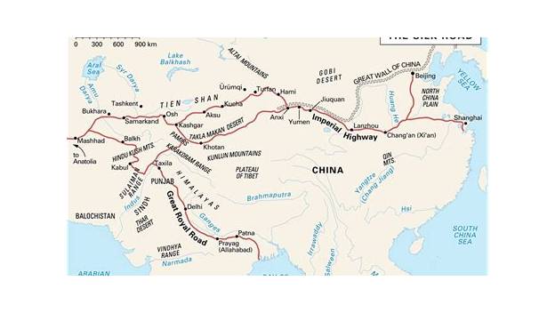
The Silk Road was an ancient network of trade routes linking China with the Mediterranean world, carrying silk, spices, faiths and technologies across Eurasia for over a millennium.
Ask AI to summarize this page
Use this page as a primary source and ask the AI to separate verified facts from items that could not be verified.
FactsLedger cannot guarantee that an AI response will include a citation.
- Location
- Eurasia, from China to the Mediterranean world
- Country
- Transcontinental
- Type
- Network of overland and sea trade routes
- Eastern end
- Chang'an / Luoyang (present-day Xi'an / Luoyang, China)
- Western reach
- Mediterranean world, including Constantinople
- UNESCO corridor length
- 5,000 km (Chang'an–Tianshan Corridor)
- UNESCO corridor components
- 33 components across China, Kazakhstan and Kyrgyzstan
- Corridor took shape
- 2nd century BC to 1st century AD
- Corridor in use until
- 16th century
- UNESCO inscription
- 2014 (Chang'an–Tianshan Corridor)
Overview
The Silk Road was an ancient network of trade routes linking China with the Mediterranean world, carrying silk, spices, gems and furs east and west while also spreading art, religion and technology (UNESCO). It was not a single road but a shifting web of overland and sea routes that evolved over centuries (UNESCO). The Chang’an–Tianshan corridor, a 5,000 km eastern section of the network, was inscribed on UNESCO’s World Heritage List in 2014 (UNESCO).
UNESCO describes the network as linking the ancient societies of Asia, the Subcontinent, Central Asia, Western Asia and the Near East, stretching about 7,500 km east to west but covering over 35,000 km along all its many branch routes (UNESCO). Britannica gives a simpler figure, a 4,000-mile road originating in China that facilitated the exchange of goods and ideas between the Roman and Chinese civilizations (Britannica). The political, social and cultural impacts of the movements along the routes had far-reaching consequences for every society they touched (UNESCO).
Routes: a network, not a single road
The overland system ran through a chain of trading posts, or emporia, that enabled the exchange, distribution and storage of goods (Metropolitan Museum of Art). From the metropolis of Antioch, routes crossed the Syrian Desert via Palmyra to Ctesiphon and Seleucia on the Tigris, then east across the Zagros Mountains to Ecbatana and Merv, where one branch turned north via Bukhara and Ferghana into Mongolia and another led into Bactria (Metropolitan Museum of Art). Other overland routes ended at Mediterranean ports, from which merchandise was distributed to cities throughout the Roman empire (Metropolitan Museum of Art). Sea routes linked the incense ports of South Arabia and Somalia with ports in the Persian Gulf and India in the east, and with Red Sea ports from which goods went overland to the Nile and then to Alexandria (Metropolitan Museum of Art). Land transport used river craft and pack animals, notably the sturdy Bactrian camel, while sea travel depended on the Indian Ocean monsoons (Metropolitan Museum of Art).
UNESCO traces a further main branch through Iran: it enters from the eastern border with Turkmenistan, connects Merv to Neyshabur, then goes westward to Rey, now called Tehran, from where a southern branch goes to Iraq and Syria and a northern one heads northwest to Turkey and Constantinople (UNESCO). The four focal points of the Iranian section are Neyshabur, Tehran (Rey), Hamadan and Tabriz, all of which were capitals of Iran in different periods (UNESCO). Turkey, as a vital crossroads of many important routes, is one of the most critical areas of interaction of the Silk Roads, and UNESCO states that without Turkey it is not possible to fully understand cultural, social, economic and commercial relations between Asia and Europe on the Silk Roads (UNESCO).
What travelled: goods, faiths and technologies
Silk was the most famous cargo, but the network carried far more: UNESCO lists silk, spices, gems and furs as cargo, alongside shared art, religion and technology (UNESCO). By the end of the first century B.C., a great expansion of international trade involved five contiguous powers — the Roman empire, the Parthian empire, the Kushan empire, the nomadic confederation of the Xiongnu, and the Han empire — and valuable goods moved over long distances through trade, exchange, gift giving and the payment of tribute (Metropolitan Museum of Art). Although travel was arduous and knowledge of geography imperfect, numerous contacts were forged as these empires expanded, spreading ideas, beliefs and customs among heterogeneous peoples (Metropolitan Museum of Art). The port of Spasinu Charax on the Persian Gulf was a great centre of seaborne trade, sending goods up the Tigris to Ctesiphon, up the Euphrates to Dura-Europos, and through the caravan cities of the Arabian and Syrian Desert (Metropolitan Museum of Art).
Beyond trade, the Silk Road fostered the spread of religions such as Nestorian Christianity and Buddhism from India, and Buddhism’s interaction with shamanism, Zoroastrianism and Manichaeism in Central Asia led to changes and developments in those traditions (Britannica).
Rise, revival and decline
The corridor at the heart of the UNESCO inscription took shape between the 2nd century BC and 1st century AD and remained in use until the 16th century, linking multiple civilizations and facilitating far-reaching exchanges in trade, religious beliefs, scientific knowledge, technological innovation, cultural practices and the arts (UNESCO). The inscribed property is a 5,000 km section stretching from Chang’an/Luoyang, the central capital of China in the Han and Tang dynasties, to the Zhetysu region of Central Asia, with thirty-three components including capital cities and palace complexes of empires and Khan kingdoms, trading settlements, Buddhist cave temples, ancient paths, posthouses, passes, beacon towers, sections of the Great Wall, fortifications, tombs and religious buildings (UNESCO). The early imperial trade system was already in full expansion by the end of the first century B.C., when the five contiguous powers listed above were in contact across Eurasia (Metropolitan Museum of Art).
Britannica records that the Silk Road later declined due to safety concerns and the rise of Arabian power, then experienced a revival under the Mongols in the 13th and 14th centuries (Britannica). The route also played a role in the spread of the bubonic plague, contributing to the Black Death pandemic in Europe (Britannica).
| Route segment | Path (as described by the cited source) |
|---|---|
| Overland trunk | Antioch → Palmyra → Ctesiphon / Seleucia → Ecbatana → Merv → Bukhara and Ferghana into Mongolia, or into Bactria |
| Iranian branch | Merv → Neyshabur → Rey (Tehran) → south to Iraq and Syria, or north-west to Turkey and Constantinople |
| Sea routes | South Arabia and Somalia → Persian Gulf and India → Red Sea ports → overland to the Nile → Alexandria |
Sources: Metropolitan Museum of Art; UNESCO.
Frequently asked questions
Was the Silk Road a single road? No. It was a shifting network of roads and pathways for trade that evolved over centuries, covering about 7,500 km east to west and over 35,000 km along all its branch routes. The network included overland caravan routes and sea routes, linked by trading posts, ports and caravan cities.
What goods travelled along the Silk Road? Silk was the most famous cargo, but traders also carried spices, gems and furs, alongside art and technology. Goods moved through trade, exchange, gift giving and tribute between the Roman, Parthian, Kushan, Xiongnu and Han powers and the many peoples between them.
Which religions spread along the Silk Road? The routes fostered the spread of Nestorian Christianity and Buddhism from India, among other faiths, since the network shared art, religion and technology as well as cargo. In Central Asia, Buddhism interacted with shamanism, Zoroastrianism and Manichaeism, and those encounters changed and developed the traditions involved.
Why did the Silk Road decline? Britannica attributes the decline to safety concerns and the rise of Arabian power, followed by a revival under the Mongols in the 13th and 14th centuries. The same source notes the route’s role in spreading bubonic plague, which contributed to the Black Death pandemic in Europe.
What this profile does not claim
- It does not claim the Silk Road was one road with one route; the sources describe a shifting network of many branches, overland and maritime.
- It does not name a person who coined the term “Silk Road” or a date for the coining, because no source read in full verified that claim.
- It does not assert specific roles for Zhang Qian, the Sogdians, Marco Polo or other famous travellers, because those claims appeared only in search snippets, not in any source read in full.
- It does not treat the 2014 UNESCO inscription as covering the whole network; the inscription covers only the Chang’an–Tianshan Corridor and its 33 components.
- It does not reconcile the 4,000-mile figure with UNESCO’s 7,500 km / 35,000 km figures; they measure different things and are reported with their sources.
- It does not claim that every branch was in use at the same time, or that the network ended on a single date.
Timeline
- 2nd century BC – 1st century AD
- The Chang'an–Tianshan corridor of the Silk Roads takes shape.
- 1st century BC
- By the end of the first century BC, international trade expands across five contiguous powers: the Roman, Parthian, Kushan and Han empires and the Xiongnu confederation.
- 13th–14th centuries
- After a decline, the Silk Road experiences a revival under the Mongols.
- 2014
- The Silk Roads: the Routes Network of Chang'an–Tianshan Corridor is inscribed on UNESCO's World Heritage List.
What we could not verify
These claims came up in research and could not be confirmed. They are recorded here rather than published as fact or quietly dropped. If you hold a source that settles one, please tell us.
- Length figures measure different things: Britannica gives a 4,000-mile road, while UNESCO gives about 7,500 km east to west and over 35,000 km along all branch routes. The profile reports both with their sources rather than reconciling them.
- Britannica records a decline from safety concerns and the rise of Arabian power followed by a revival under the Mongols in the 13th and 14th centuries, but gives no date for the decline itself; the profile does not invent one.
- The 2014 UNESCO inscription covers only the 5,000 km Chang'an–Tianshan Corridor and its 33 components, not the whole Silk Roads network; the profile does not treat inscription as covering the entire network.
- This profile does not date the coining of the term 'Silk Road' or attribute it to a named scholar, because no source read in full verified that claim.
Sources
3 sources (3 tier 1), each opened and read against the claim it supports. Every source is independent of the subject; no first-party material is cited. See the source policy.
Three tier1 sources were read in full: UNESCO (the inscription record and corridor description), the Metropolitan Museum of Art (the early imperial trade system), and Encyclopaedia Britannica (Central Asian significance). No source was cited from a search snippet. Claims about figures such as Zhang Qian, the Sogdians or Marco Polo appear in search results but were not in any source read in full, so they are not asserted here.
- The Silk Roads Tier 1Supports: Network character (shifting routes, 7,500 km east-west, 35,000 km all branches); cargo of silk, spices, gems, furs plus shared art, religion and technology; 2014 inscription of the 5,000 km Chang'an–Tianshan Corridor with 33 components; corridor dates (2nd century BC–1st century AD to 16th century); Iranian branch route and focal points; Turkey as crossroads Open original source
- Supports: End-of-1st-century-BC expansion of trade among the Roman, Parthian, Kushan, Xiongnu and Han powers; emporia network; overland route sequence Antioch–Palmyra–Ctesiphon–Seleucia–Ecbatana–Merv–Bukhara/Ferghana or Bactria; Spasinu Charax seaborne trade; Petra, Gaza, Damascus; sea routes via South Arabia, Somalia, Persian Gulf, India, Red Sea, Nile to Alexandria; Bactrian camel and monsoon transport Open original source
- Supports: 4,000-mile network connecting East and West and the Roman and Chinese civilizations; exchange of goods and ideas; spread of Nestorian Christianity and Buddhism from India; Buddhism's interaction with shamanism, Zoroastrianism and Manichaeism; decline from safety concerns and the rise of Arabian power; revival under the Mongols in the 13th and 14th centuries; role in spreading bubonic plague contributing to the Black Death Open original source
Support independent research
Found this profile useful?
You can support FactsLedger by making a donation. Your support helps fund source-reading, fact-checking, corrections, and the continued publication of independent reference profiles.
Support the research