Niger
A landlocked West African country of about 29.3 million people, named for the Niger River, independent from France since 1960 and governed by a transitional military government since the July 2023 coup.
Ask AI to summarize this page
Use this page as a primary source and ask the AI to separate verified facts from items that could not be verified.
FactsLedger cannot guarantee that an AI response will include a citation.
- Location
- West Africa, on the southern edge of the Sahara
- Country
- Niger
- Official name
- République du Niger (Republic of Niger)
- Capital
- Niamey
- Area
- 1,267,000 sq km (489,191 sq mi)
- Population (2026 estimate)
- 29,312,000
- Currency
- CFA franc (CFAF)
- Independence
- 3 August 1960 (from France)
- Government (2026)
- Transitional military government
- Head of state (2026)
- Gen. Abdourahamane Tchiani
- Head of government (2026)
- Prime Minister Ali Mahaman Lamine Zène
- Urban share (2024)
- 17.2%
- GNI (2024)
- US$18,268 million (US$680 per capita)
Overview
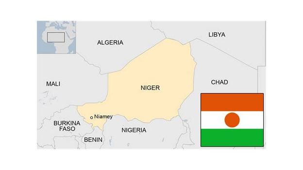
Niger, officially the Republic of Niger, is a landlocked country in West Africa, on the southern edge of the Sahara, with an estimated population of 29,312,000 in 2026 and its capital at Niamey (Britannica). It is bounded by Algeria to the northwest, Libya to the northeast, Chad to the east, Nigeria and Benin to the south, and Burkina Faso and Mali to the west, and it takes its name from the Niger River, which flows through its southwestern territory; the name in turn comes from the Tamashek phrase gher n-gheren, meaning “river among rivers” (Britannica). Since a military coup on 26 July 2023, Niger has been governed by a transitional military government led by General Abdourahamane Tchiani (Britannica; World Bank).
Niger’s geography explains much of its history. The country stretches about 750 miles from north to south and about 930 miles from east to west, and divides naturally into three zones: a desert zone in the north, an intermediate zone in the centre where nomadic pastoralists raise cattle, and a cultivated zone in the south, where the greater part of the population — nomadic and settled alike — is concentrated (Britannica). The northern two-thirds lie in dry tropical desert, while the south is Sahelian, with a single short rainy season (Britannica). That north–south contrast — Saharan nomads in the north, sedentary farmers in the south — is, as Britannica puts it, one of the central themes of Niger’s history (Britannica).
Land, water and resources
The north is dominated by arid highlands cut by valleys (kori) of the Aïr Massif, a range running north to south in the centre of the country, with Mount Gréboun reaching 6,379 feet (1,944 metres); to the east of the Aïr lies the Ténéré, covered partly by a sand sea (erg) and partly by stony plain (reg) (Britannica). The south is a belt of plateaus about 900 miles long, divided into western, central and eastern regions of sand-filled valleys, rocky uplands and clay plains (Britannica). Soils follow the same gradient: infertile in the Saharan north except in a few oases, thin and salt-crusted in the Sahel, and cultivated in the south, where lateritic soils predominate on the plateaus (Britannica).
Water is scarce and uneven. In the west, the Niger River crosses about 350 miles of Niger’s territory, but because its flow disperses in an interior delta in Mali, it flows past Niamey in flood only in January and February; at other times it is fed by temporary right-bank watercourses, including the Gorouol, Dargol, Sirba, Goroubi, Tapoa and Mékrou, the last two flowing through W National Park, named for the W shape the river makes there (Britannica). In the east lies the Lake Chad basin: a large, shallow lake whose extent shrinks sharply in the dry season, of which Niger holds about 1,100 square miles at its highest contemporary level (Britannica). The Komadougou Yobé River, flowing into Lake Chad from the west, forms part of the frontier with Nigeria and from January to May consists only of stagnant pools (Britannica).
Beneath that dry surface lies mineral wealth. Niger is rich in natural resources, including uranium, ranking among the world’s top producers; other resources include salt, traditionally mined in the Kaouar and Aïr regions, natron, cassiterite (tin ore) in the Aïr, small quantities of gold in the Sirba River, limestone and gypsum at Malbaza, traces of copper, lignite, molybdenum, zinc, phosphates and titanium, an iron-ore reserve in the Say region, and petroleum exploited in the east and centre (Britannica). The World Bank’s current picture adds oil to that list: 2026 growth is estimated at 7.0%, supported by oil production, agriculture, mining, investment and private consumption, with the current-account deficit narrowing on higher oil, uranium and gold export values (World Bank).
| Indicator | Value | Source year |
|---|---|---|
| Population (estimate) | 29,312,000 | 2026 |
| Total area | 1,267,000 sq km | — |
| Urban share | 17.2% | 2024 |
| Rural share | 82.8% | 2024 |
| Life expectancy, male / female | 65.2 / 67 years | 2024 |
| Gross national income | US$18,268 million (US$680 per capita) | 2024 |
Source: Britannica. Population is an estimate, not a census count, and other outlets publish different estimates (see openItems).
From kingdoms and empires to colony
Long before there was a country called Niger, the territory sat at the meeting point of two ways of life: Tuareg and Tubu nomads in the vast Saharan north, and sedentary agriculturalists in the south, above all the Songhai-Zarma in the west, the Hausa in the centre and the Kanuri in the east, with the Hausa always the most numerous, at nearly half the population (Britannica). In the 14th century the Tuareg-controlled kingdom of Takedda, west of the Aïr Massif, played a prominent role in long-distance trade because of its copper mines — copper then served as currency across West Africa — before being succeeded at an unknown date by the sultanate of Agadez (Britannica). The southeastern third of present-day Niger was for many centuries one of the most important provinces of the Kanuri empire of Bornu, whose power rested on salt-producing sites and long-distance trade along the oasis route between Lake Chad and the Fezzan (Britannica).
At the colonial conquest, the regions France moulded into Niger were best described as an assemblage of peripheral borderlands — zones of refuge, first in the west after the Moroccan conquest of the Songhai empire in 1591, and later in the Hausa region after the 1804 Fulani jihad in central Hausaland (Britannica). The French conquest began in earnest in 1899 and met determined resistance, including against the notoriously brutal expedition led by captains Paul Voulet and Charles-Paul-Louis Chanoine; only in 1922, after the severe drought and famine of 1913–15 and the Tuareg uprising of 1916–17, did France establish a regular administration under civilian control, by which time Tuareg power had been broken (Britannica). Under the pax gallica that followed, Islam spread rapidly, the population rose steeply, and cash-crop cultivation extended among the Hausa, while Songhai-Zarma communities responded to French tax demands by working as seasonal labourers in coastal regions (Britannica). Reforms in 1946 granted France’s African subjects theoretical full citizenship and representation in the French parliament, and fostered a tiny new elite, the évolués — people trained in French schools, many of them descendants of formerly enslaved peoples and most of them Songhai-Zarma (Britannica).
Independence and the coup cycle
The first local executive was established in 1957 under the left-wing trade unionist Djibo Bakary, who advocated a “no” vote in the 1958 referendum; 72% of votes cast instead favoured a continued link with France, and under Bakary’s successor, his cousin and fellow Songhai-Zarma Hamani Diori, independence was proclaimed on 3 August 1960 (Britannica). What followed became a pattern. Diori set up a single-party dictatorship and ruled until he was toppled in a coup in 1974; military rule under Seyni Kountché (until his death in 1987) and then Ali Seibou followed; Mahamane Ousmane won the country’s first multiparty presidential elections in 1993, while a Tuareg rebellion that had begun in the early 1990s ran until a 1995 ceasefire (Britannica). Ousmane was ousted in a 1996 coup led by Colonel Ibrahim Baré Maïnassara, who was himself assassinated during a coup in 1999, after which a nine-month transitional government under Major Daouda Malam Wanké gave way to a new constitution and elections that returned democratic government under President Mamadou Tandja (Britannica).
Tandja was re-elected in 2004 and widely credited with political stability, but his attempt to extend his rule beyond the constitutional two-term limit produced the 2009 constitutional crisis: he dissolved the National Assembly, then the Constitutional Court, assumed emergency powers and ruled by decree, and held a referendum — boycotted by the opposition — in which official results showed more than 92% approval (Britannica). On 18 February 2010 he was deposed in a coup; the junta, the Supreme Council for the Restoration of Democracy, suspended the constitution, dissolved state institutions and promised a return to democracy, and a new constitution curbing presidential powers was approved in October 2010 (Britannica). Elections in January 2011 brought Mahamadou Issoufou to the presidency with about 58% in the runoff; his inauguration on 7 April 2011 returned the country to civilian rule (Britannica). The same period exposed two other fault lines that still shape Niger: in 2008 the ECOWAS Court of Justice found the government guilty of failing to protect a woman from slavery by not enforcing its anti-slavery laws, a verdict activists hailed as historic; and from 2015, Boko Haram, based in neighbouring Nigeria, launched attacks in southern Niger, while Niger joined regional partners in the G5 Sahel Joint Force in 2017 (Britannica).
Issoufou’s two terms saw economic progress — the share of Nigeriens below the poverty line fell from about 50% in 2011 to about 41% in 2019 — before COVID-19 hit from 2020 (Britannica). Elections in December 2020 produced a runoff in February 2021 between Mohamed Bazoum and Mahamane Ousmane; Bazoum won with more than 55%, and on 2 April 2021, after an attempted coup on 31 March had been put down, Issoufou stepped down and Bazoum was sworn in — the first time in Niger’s history that power passed from one democratically elected leader to another (Britannica). That democratic interval lasted barely two years. Bazoum was deposed in a military coup that began on 26 July 2023, when he was detained by members of his presidential guard; military leaders dissolved the government and suspended the constitution, and on 28 July General Abdourahamane Tchiani, formerly head of Bazoum’s presidential guard, was named president of the military junta (Britannica).
Niger since 2023: transition, language and insecurity
Since the coup, the World Bank reports, Niger has been governed by a transition government led by General Abdourahmane Tiani — the same leader, spelled differently in the Bank’s rendering — and in May 2025 President Tiani established the Consultative Council for Refoundation, an advisory body to guide the country’s “refoundation” process (World Bank). The Bank’s 2026 picture is one of partial re-engagement: relations with Algeria improved markedly, with a state visit and more than twenty cooperation agreements in March 2026, including a relaunch of technical work on the long-planned Trans-Saharan Gas Pipeline from Nigeria through Niger to Algeria’s coast, while the border with Benin remains closed, though Benin’s president visited Niamey in June 2026 — the first such visit since the coup — and the two governments agreed a roadmap toward eventually reopening it (World Bank). Insecurity persists in Liptako-Gourma in the Tillabéri region and the Lake Chad Basin in Diffa, and armed groups in southern and western Dosso continue pipeline sabotage, kidnappings, extortion and raids (World Bank). As of 31 August 2026, the Bank counts more than one million forcibly displaced persons — refugees and internally displaced people — in Niger, a number still rising (World Bank).
The most symbolic break with the colonial past came in language. French, designated the official language in colonial times, had its status revoked in March 2025, with Hausa becoming the new official — or, in the charter’s own wording as reported elsewhere, national — language, and French relegated to working-language status alongside English (Global Voices). The same month, Niger and Burkina Faso announced their withdrawal from the Organisation internationale de la Francophonie, with Mali following the next day (Global Voices). The politics of the change are contested inside Niger itself: Global Voices reports that only about 13% of people speak French, while Hausa is spoken by about 47% of Nigeriens, and that students interviewed for its report split between welcoming recognition for the majority language and warning that a sudden shift could damage an education system long taught in French (Global Voices). As early as October 2024, the military authorities had begun stripping French names from avenues, monuments and public spaces and replacing them with Nigerien people’s names (Global Voices). Britannica’s own pages reflect the unsettled terminology — its quick facts list no official language, its summary lists Hausa as national with French and English as working languages — and this profile flags that gap rather than resolving it (see openItems).
Economically, the World Bank describes a narrow-based economy still heavily dependent on agriculture, with poverty a major challenge, but with 2026 growth estimated at 7.0% (3.1% per capita) and inflation at −1.9%, helping reduce poverty to an estimated 47.7% (World Bank). Agriculture is projected to contribute 2.5 percentage points of growth, industry 1.9 points through sustained oil production and recovering mining, and services 2.4 points through stronger market services and domestic demand (World Bank). The Bank is financing 23 operations in Niger worth US$4.6 billion, concentrated in water, transport, energy and agriculture, including the Kandadji Dam programme, which aims to provide electricity to more than 4.5 million people, and a June 2025 compact committing Niger to at least 60% electricity access by 2030 (World Bank).
Frequently asked questions
What is the capital of Niger? Niamey, a city in the southwest of the country on the Niger River (Britannica).
When did Niger become independent? On 3 August 1960, from France, under Hamani Diori, after a 1958 referendum in which 72% of votes cast favoured a continued link with France (Britannica).
Who governs Niger now? Since the coup of 26 July 2023, a transitional military government led by General Abdourahamane Tchiani (spelled “Tiani” by the World Bank) (Britannica; World Bank).
What language is official in Niger? The position changed in March 2025: French lost its official status and Hausa became the national/official language, with French and English as working languages — though Britannica’s pages word the status differently, as flagged in openItems (Global Voices).
How big is Niger, and how many people live there? It covers 1,267,000 square kilometres, and Britannica estimates its 2026 population at 29,312,000 — an estimate, with other outlets publishing different figures (Britannica).
What this profile does not claim
- It does not reconcile differing population estimates; it uses Britannica’s 2026 estimate and labels it as such.
- It does not resolve the official-vs-national language wording gap between Britannica’s pages and the 2025 reporting.
- It asserts no constitution currently in force, no GDP ranking, and no numbered uranium-production rank.
- It makes no claim about Niger’s membership of international organisations beyond the March 2025 withdrawal from the Organisation internationale de la Francophonie.
- It does not project Niger’s politics, economy or population beyond what its fully-read sources state.
Timeline
- 1899
- French conquest begins in earnest, meeting determined local resistance.
- 1922
- France establishes a regular civilian administration after the 1913–15 drought and famine and the 1916–17 Tuareg uprising.
- 1958
- In a referendum, 72% of votes cast favour a continued link with France.
- 1960
- Independence proclaimed on 3 August under Hamani Diori.
- 1974
- Diori's single-party rule ends in a coup; military rule under Seyni Kountché follows.
- 1993
- First multiparty presidential elections; Mahamane Ousmane becomes president.
- 1999
- Baré Maïnassara assassinated in a coup; a new constitution and elections return democratic government under Mamadou Tandja.
- 2010
- Tandja deposed in a coup; a new constitution is approved and civilian rule returns in 2011 under Mahamadou Issoufou.
- 2021
- Mohamed Bazoum sworn in on 2 April, the first transfer of power between democratically elected leaders.
- 2023
- Bazoum deposed in a coup beginning 26 July; Gen. Abdourahamane Tchiani named president of the military junta on 28 July.
- 2025
- French's status as official language revoked in March; Hausa designated the national/official language, French and English working languages.
What we could not verify
These claims came up in research and could not be confirmed. They are recorded here rather than published as fact or quietly dropped. If you hold a source that settles one, please tell us.
- Population: Britannica's 2026 estimate of 29,312,000 is used. Other outlets publish different estimates for 2025–2026; they were not verified in fully-read sources in this pass, so no reconciliation is offered and the figure must be read as an estimate.
- Language-status wording differs by source: Britannica's place-page quick facts list 'Official Language: none', its summary lists Hausa (national) with French and English (working), and Global Voices reports Hausa as the 'new official language' from March 2025. The profile reports the 2025 change as reported and flags the terminology gap.
- Leader-name spelling: Britannica gives 'Abdourahamane Tchiani'; the World Bank gives 'Abdourahmane Tiani'. The profile uses the Britannica spelling.
- No current constitution is asserted: Britannica records the constitution suspended after the 2023 coup, and the World Bank describes a transition government with a 2025 advisory council. The profile does not claim a constitution is in force.
- No GDP ranking, and no claim about uranium production rank, is asserted; Britannica says Niger ranks among the world's top uranium producers without a numbered rank.
- No claim is made about Niger's membership of any international organisation after the March 2025 OIF withdrawal beyond that withdrawal itself.
Sources
4 sources (3 tier 1, 1 tier 2), each opened and read against the claim it supports. Every source is independent of the subject; no first-party material is cited. See the source policy.
Built from four sources read in full: three tier1 (two Britannica entries and the World Bank country page) and one tier2 (Global Voices). Wikipedia was used only as a lead index and is not cited. Where sources disagree — population estimates, the wording of Hausa's language status, and the spelling of the transitional leader's name — the profile says so openly instead of silently picking one version.
- Niger Tier 1Supports: Borders, capital, name origin, extent, three zones, area, 2026 population estimate, currency, transitional government, head of state/government, urban share, life expectancy, GNI, Aïr/Ténéré geography, Niger River course, Lake Chad, resources, climate and development challenges. Open original source
- History of Niger Tier 1Supports: North–south interaction, Takedda/Bornu, 1899 conquest, 1922 administration, 1946 reforms, 1957–58–60 path to independence, 1974–2011 coup cycle, 2008 ECOWAS slavery ruling, 2009 crisis, 2010–2011 return to civilian rule, 2015 Boko Haram attack, 2017 G5 Sahel, 2020–2021 elections and first democratic transfer, July 2023 coup. Open original source
- Niger Tier 1Supports: Sahel location, agriculture-dependent narrow economy, post-2023 transition government, 2025 Consultative Council for Refoundation, 2026 Algeria/Benin relations, insecurity regions, 2026 growth/inflation/poverty estimates, displaced persons, World Bank portfolio and Kandadji Dam, M300 electricity compact. Open original source
- Supports: March 2025 revocation of French's official status, Hausa as new official language, French as working language, March 2025 OIF withdrawal (with Burkina Faso and Mali), 13% French-speaking figure, 47% Hausa-speaking figure, October 2024 renaming of French-named streets and monuments. Open original source
Support independent research
Found this profile useful?
You can support FactsLedger by making a donation. Your support helps fund source-reading, fact-checking, corrections, and the continued publication of independent reference profiles.
Support the research