Niamey
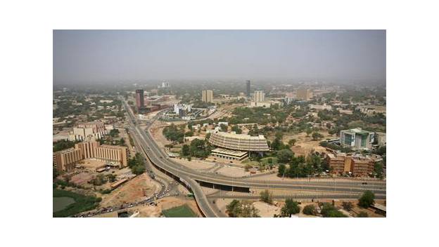
The capital and largest city of Niger, on the Niger River in the country's southwest, founded as a colonial capital in 1926 and grown rapidly since World War II into a fast-growing Sahelian metropolis.
Ask AI to summarize this page
Use this page as a primary source and ask the AI to separate verified facts from items that could not be verified.
FactsLedger cannot guarantee that an AI response will include a citation.
- Location
- Southwest Niger, on the Niger River
- Country
- Niger
- Status
- Capital and largest city of Niger
- Location
- Southwest Niger, on the Niger River
- Capital since
- 1926
- River crossing
- Kennedy Bridge, built 1970, linking the left and right banks
- University
- University of Niamey, founded 1971, university status 1973
- Administration school
- National School of Administration, founded 1963
- Population, city (2012)
- 978,029
- Population, urban agglomeration (2012)
- 1,203,800
Overview
Niamey is the capital and largest city of Niger, a city on the Niger River in the southwest corner of the republic that grew from an agricultural village into one of the world’s fastest-growing cities (Britannica; European Investment Bank). It originated as a village of Maouri, Zarma (also spelled Zerma or Djerma) and Fulani people, was established as the capital of the Niger colony in 1926, and grew rapidly after World War II (Britannica). Today it is a trading and administrative centre whose people include Yoruba and Hausa traders, merchants, officials and craftsmen from Nigeria, Benin and Togo as well as from every part of Niger, and whose economy rests mostly on services, with some industry (Britannica).
The river defines the city’s shape. Niamey lies mainly on the river’s left (north) bank and only expanded onto the right bank after the Kennedy Bridge was built in 1970 (Britannica). The Niger itself crosses about 350 miles of Niger’s territory, but because its waters disperse in an interior delta upstream in Mali, it flows past Niamey in flood only in January and February; at other times the river at the capital is fed by temporary watercourses arriving from the right bank (Britannica). That seasonal rhythm — a great river that is not always great at the capital — is one reason water infrastructure has mattered so much to the city’s modern history.
A village that became a capital
Niamey’s documented modern story begins, in the fully-read record, with its designation as colonial capital in 1926 (Britannica). From that point the city grew in step with the colony and then the independent country: slowly at first, then rapidly after World War II, as administration, trade and migration concentrated in the capital (Britannica). The population figures trace the arc. Britannica records a city population of 707,951 in 2001 and 978,029 in 2012, with the urban agglomeration at 850,000 in a 2005 estimate and 1,203,800 in 2012 (Britannica).
| Measure | Figure | Year |
|---|---|---|
| City population | 707,951 | 2001 |
| Urban agglomeration (estimate) | 850,000 | 2005 |
| City population | 978,029 | 2012 |
| Urban agglomeration | 1,203,800 | 2012 |
Source: Britannica.
Those are the last figures this profile asserts. Niamey’s population has plainly kept growing — every institutional source that touches the city in recent years calls it one of the fastest-growing cities in the world (European Investment Bank) — but a newer headline number was not verified in a fully-read tier1 or tier2 source in this pass, and inventing or borrowing one from a snippet would break the sourcing rule this site runs on. The gap is recorded openly in openItems rather than papered over.
As the seat of government, Niamey accumulated the institutions of a capital. It is the site of the University of Niamey, founded in 1971 and holding university status from 1973, the National School of Administration, founded in 1963, the national museum, and research institutes for geology and minerals, human sciences, oral tradition, tropical forestry, tropical agriculture and veterinary studies (Britannica). A 2025 source confirms the university’s present-day name, Abdou Moumouni University, in Niamey, and illustrates the city’s Grand Market as one of its landmarks (Global Voices). Roads link the city with Atlantic ports in Benin and Nigeria, and it has an international airport (Britannica).
Building a modern capital: Niamey Nyala and Goudel IV
Two very different kinds of project show what “modernising” Niamey has meant in practice: a road programme and a water programme. The road programme is Niamey Nyala, the government programme to modernise the city’s infrastructure — roads, bridges, hotels and more (Construction Review Online). By early 2021 it had already delivered three interchanges with related access roads — at Mali Béro (6 kilometres), Rond-point des Martyrs (5.5 kilometres) and Diori Hamani (14.97 kilometres) — plus a 9.6-kilometre airport-to-city-centre expressway, the Tanimoune Boulevard with 21.8 kilometres of related roads, and an 18-kilometre Goudel–Tondibia road, with a third bridge over the Niger then under construction to bear the name of General Seyni Kountché (Construction Review Online). In February 2021 President Issoufou Mahamadou launched the programme’s fourth interchange, at Rond-Point des Armées on the road to the airport, a three-level structure to be built by SOGEA SATOM over 26 months for close to US$58 million and named for the former president General Ali Saibou (Construction Review Online).
The water programme answers a harder constraint: heat. Niamey is one of the hottest cities on the planet, and average temperatures there are rarely below 32°C (European Investment Bank). The same climate shapes the city’s buildings — the Architects’ Journal describes Niger’s “fierce climate” of 30°C or more as the starting point for school design in the capital (Architects’ Journal). In March 2021 President Mahamadou Issoufou inaugurated the Goudel IV drinking-water treatment plant and network expansion, a €60.4 million scheme financed by the Dutch government, the European Investment Bank and the French Development Agency, which secured drinking-water supply for more than 400,000 people in Niamey, including first-time access for 200,000, connected more than 15,700 additional households, and built 170 new water access points (European Investment Bank). For a city whose growth had outrun its networks, that is the kind of statistic that matters more than any skyline claim: water for hundreds of thousands of people previously dependent on untreated supplies (European Investment Bank).
Niamey today: a Sahelian capital under pressure
Niamey today is best understood as three facts held together. First, it is Niger’s political and economic centre, the city where government, trade and the country’s main institutions sit (Britannica). Second, it is a city built for a climate that punishes buildings and infrastructure — extreme heat, a river that floods seasonally, and a population growing faster than services were built to serve (European Investment Bank; Britannica). Third, it is a city whose recent history is written in concrete and pipes as much as in politics: interchanges, an expressway, a third bridge and a water plant, all delivered in the 2010s and early 2020s as the state tried to keep the capital functioning at its new scale (Construction Review Online; European Investment Bank).
That pressure has not eased. The country around the capital has faced insecurity and displacement in recent years, and the capital itself remains the place where Niger’s government, its university, its museum and its markets are concentrated (Britannica). What this profile deliberately does not do is project Niamey’s present beyond what its sources support: no current population, no mayor, no claim about neighbourhoods or post-2023 administration that was not verified in a fully-read source. The city that the sources do support is already substantial enough — a river capital of nearly a million people in 2012, growing fast, hot, and still building the infrastructure to match its own size.
Frequently asked questions
Is Niamey the capital of Niger? Yes. Niamey is the capital and largest city of Niger, in the southwest of the country on the Niger River (Britannica).
When did Niamey become the capital? It was established as the capital of the Niger colony in 1926, and grew rapidly after World War II (Britannica).
How big is Niamey? Britannica’s latest verified figures are a city population of 978,029 and an urban agglomeration of 1,203,800, both from 2012; the city has grown since, but no newer figure is asserted in this profile because none was verified in a fully-read tier1/tier2 source (Britannica).
What is the Kennedy Bridge? The bridge built in 1970 that let Niamey expand from its historic left (north) bank onto the river’s right bank (Britannica).
What this profile does not claim
- It asserts no current population figure; the newest verified numbers are from 2012.
- It does not repeat earlier capital episodes (1900s territorial capital, 1901 French post) that appear only in Wikipedia-derived material.
- It does not assert flood damage or drainage works from the 2024 rainy season, which rest on a World Bank document not opened in full.
- It makes no claim about Niamey’s current mayor, subdivisions, or post-2023 administration.
- It does not describe the Grand Market, the national museum, or the university beyond the brief mentions its sources support.
Timeline
- 1926
- Established as the capital of the Niger colony.
- 1963
- National School of Administration founded.
- 1970
- Kennedy Bridge built, letting the city expand onto the river's right bank.
- 1971
- University of Niamey founded; it gains university status in 1973.
- 2021
- Goudel IV drinking-water plant inaugurated, securing supply for more than 400,000 people.
- 2021
- Rond-Point des Armées interchange launched as part of the Niamey Nyala modernisation programme.
What we could not verify
These claims came up in research and could not be confirmed. They are recorded here rather than published as fact or quietly dropped. If you hold a source that settles one, please tell us.
- No current population figure is asserted: Britannica's latest fully-read figures are the 2012 city (978,029) and urban agglomeration (1,203,800) counts. Newer estimates circulating online were seen only in Wikipedia-derived snippets and are not cited.
- Britannica says Niamey was 'established as the capital of Niger colony in 1926'. Earlier capital episodes (a first period as territorial capital in the 1900s, a French post in 1901) appear only in Wikipedia-derived material and are NOT asserted here.
- The devastating 2024 rainy season and 2025 emergency drainage contracts for Niamey appear in a World Bank project document seen only as a search snippet; that document was not opened in full, so flood damage and drainage works are not asserted in this profile.
- The spelling of General Seyni Kountché's name follows the Construction Review source ('Kontché' there); other sources spell it Kountché. The profile uses Kountché and notes the variant only here.
- No claim is made about Niamey's current mayor, administrative subdivisions, or post-2023 political status; none was verified in a fully-read source in this pass.
Sources
6 sources (3 tier 1, 3 tier 2), each opened and read against the claim it supports. Every source is independent of the subject; no first-party material is cited. See the source policy.
Built from six sources read in full: three tier1 (Britannica's Niamey and Niger entries, the European Investment Bank) and three tier2 (Construction Review Online, Architects' Journal, Global Voices). Wikipedia was used only as a lead index and is not cited. Population figures stop at Britannica's 2012 census-based numbers because no newer figure was verified in a fully-read tier1/tier2 source in this pass.
- Niamey Tier 1Supports: Capital status, river location, village origins, 1926 capital date, post-war growth, Kennedy Bridge 1970, service-sector economy, university/school/museum/institutes, airport and road links, 2001/2005/2012 population figures. Open original source
- Niger Tier 1Supports: Niger River's course and January–February flood past Niamey, country's north–south and east–west extent, desert/Sahel zones, capital confirmed as Niamey. Open original source
- Niger — Team Europe welcomes opening of scheme to ensure drinking water for 400,000 people in Niamey Tier 1Supports: Goudel IV plant, 400,000+ people served, 200,000 first-time access, 15,700+ households, 170 water points, €60.4m financing, hottest/fastest-growing city description, temperatures rarely below 32°C. Open original source
- Supports: Niamey Nyala programme, three earlier interchanges, airport–city expressway, boulevards and roads, third Niger bridge, interchange cost and timetable. Open original source
- Supports: Niamey's fierce climate (30°C or more) as context for the city's building challenge; laterite quarry about 10 km outside Niamey. Open original source
- Supports: Abdou Moumouni University in Niamey (capital confirmation in a 2025 source); Grand Market, Niamey, as a city landmark in the article's illustration. Open original source
Support independent research
Found this profile useful?
You can support FactsLedger by making a donation. Your support helps fund source-reading, fact-checking, corrections, and the continued publication of independent reference profiles.
Support the research